
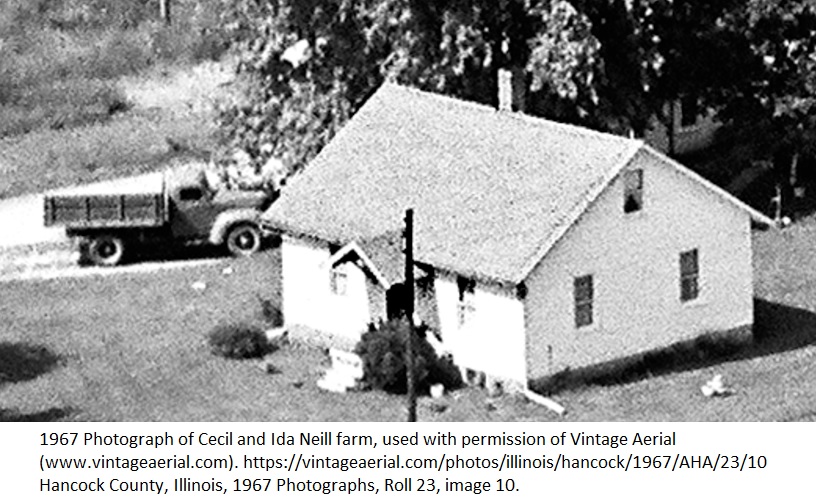
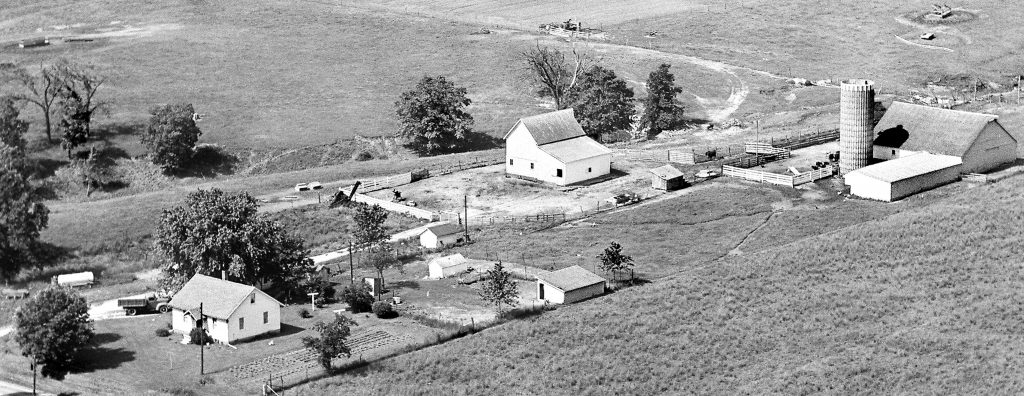
I can almost see a barefoot Grandma Neill in the backyard of this picture, headed towards the chicken house to gather the eggs. But my favorite part of this image is my Grandpa’s truck sitting in the driveway. The magnified illustration focusing on the house and the truck is only a portion of the picture of my Grandparents’ farm taken “from the air” one year before my Grandpa Neill’s death.
The house no longer stands and there’s a Kirby machine shed due west of where the home was (and slightly south west of the chicken coop), but the larger barns and silo are still there. A few of the smaller outbuildings have been razed. Grandma’s garden can be seen north of her house and there appear to be a few chickens showing as well. Not everything that looks like chickens are chickens–a few of those white blurry images are flowerpots Grandma made from retired kitchen pots.
The images included in this post have been reproduced here with the permission of Vintage Aerial. Some of the outlying farmland where no buildings are seen has been cropped from the original photo. This image is one of millions that Vintage Aerial hosts from the era on their site. There is one difference: the overview of the farm shown in this post is not the image that can be viewed for free on the Vintage Aerial site. It’s the image that can be purchased from the site for personal use and personal printing.
The images document rural America at one brief moment in time.
The images are not perfect as they were taking from a flying airplane with 1960s-era technology. They were not created with modern digital cameras and enhancement technology cannot improve what was not in the image. There’s just one challenge: you have to find the image yourself. This is not a genealogical database that has a names attached to every image and where you can type in a name and have a result magically appear for you.
A Different Perspective
The geographic organization of the photographs is as specific as the county. After that (with an exception we will discuss), searchers will have to manually search for images. This can be a time-consuming process and is not necessarily as easy as you think. Looking at things from above is a different perspective and takes a little adjustment. Think of it as getting used to reading someone’s handwriting. Even when one is familiar with the area, as I was with my paternal grandparents’ farm (shown in the illustrations) and my parents’ farm (located only a half mile from each other), it takes a while to start recognizing houses or barns. The occasional picture is taken from “the back” of the property. This, at least for me, makes recognition somewhat more difficult–especially for farms that I only ever saw from the road.
Things can be a little more challenging if your memory does not extend to the year the photographs were taken. Things change. Buildings are torn down. Buildings are put up. Tree lines are bulldozed. Timber is cleared. Time marches on. The model year of vehicles shown should not present a problem.
Order of the Pictures
Fortunately the pictures are in the sequence they were taken by the pilot, so there is some geographic ordering to them. Pilots tended to fly along roads, likely because it made identification of the locations easier later. The problem is there’s always the time when they have, so to speak, flown themselves into a corner and there is a geographic jump in the images. Users of the site may find it helpful to have a contemporary plat book handy. Even if one is familiar with the area it helps to have one so that located places can be marked with the roll and image numbers used on the site.
The home I few up in was only a half a mile from my Grandparents’ farm, but it was quite a few images away–simply because of how the pilot flew and took pictures. One has to turn around somewhere. The location of these farms is two dimensional and pilots (and census takers) do their work in lines. Those lines may be criss-crossed, but every so often there has to be a point where one turns around and goes back. Do not assume places that are “close” will be “close” in terms of image location. That is not necessarily true.
When I viewed the home I grew up in and the nearby images, I could see how the pilot flew north from the town of Carthage along the road my home was on and took pictures of every home on the east side of the road for about two miles. He then turned around and took pictures on the west side of the road. This is easier to notice if you have a map or are familiar with the area. My maternal grandparents lived seven miles south of where I grew up and I’m not as familiar with that area–which has made locating their home more difficult.
Getting Help
The website that hosts the images allows users to interact with them and post comments. These comments are searchable. I would start my search by searching the images of the county of interest for the last being searched for. If that does not locate the family of interest, search for nearby families, churches, schools, etc. in an attempt to pinpoint which section of the images contain the area of the county in which your family lived. Keep in mind that anyone can tag images and that there can be mistakes.
Perspective will throw you off when viewing these images. Some pictures were taken “from the back” and if the only view you ever had was “from the road,” recognizing a place with which you are familiar can occasionally be a challenge. Additional challenges are houses and barns that were torn down between the photography and your personal memory, vegetation that has been changed significantly, etc.
Lastly, consider letting others who may know the area know about the site. They may be able to help. Relatives, former neighbors, classmates, etc. who are not necessarily interested in genealogy or family history may find it a challenge to find their farm or property in the image set. Any images that can be identified may help you find your own people.
Reminders and Suggestions
- Have a plat map of the area showing landowners as close to picture time as possible.
- Search the database of located places for last names of neighbors, landmarks, schools, churches, etc.
- Keep track of places that you have located–preferably on a map.
- Track image sets that have been viewed.
- Ask for help from locals familiar with the area.
- Add identifying information to any images on the site that you know.

No responses yet