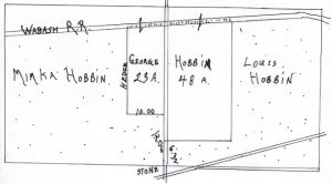
The settling of estates frequently requires surveys and metes and bounds descriptions of property, regardless of whether the property is in a state where sections and townships are used. The image at the top of this post is from a survey conducted in 1940 apparently to settle up the estate of John Habben. The survey also includes a metes and bounds description of the property which is not included here.
This plat was recorded in April of 1940 in Hancock County, Illinois, for property in sections 21 and 22 of Prairie Township (Township 5-7). John Habben owned the southeast quarter of section 21 (which is where Mimka Habben’s property was located) and the southwest quarter of section 22 (which is where Louis Habben’s property was located).
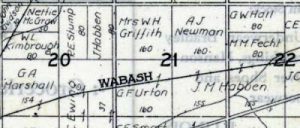
John Habben, the father of these three men, actually owned an additional 80 acres in Prairie Township. The 1908 Hancock County plat book shows the Habben property–80 acres in Section 20 (J. Habben), 155 acres in section 21 (J. M. Habben), and 155 acres in section 22 (J. M. Habben).
The 80 acres in section 20 was given to John’s son Henry and the 310 acres in sections 21 and 22 was split among the Mimka, Louis, and George as shown in the first illustration.
The 1908 plat book is not entirely accurate–as they often aren’t. The highway running along the southern part of the farm in section 22 is the problem. The survey plat indicates that the Habbens actually owned a tiny sliver of land in section 27 which is to the south of section 22. This triangular piece of property is indicated in brown on the image below which was enlarged from the survey map.
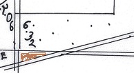
It is simply too small for the county atlas to show correctly. In fact the survey simply refers to it as “strip off the north west quarter of section 27 about one rod wide and lying north of the hedge fence.”
These maps are usually filed in the local recorder’s office in the county where the property is located. Finding them may take a little patience. Locations that have a tract index (also known as a parcel or lot index) usually include references to surveys in their appropriate sections of that index. That’s how the survey map in this illustration was located.


No responses yet