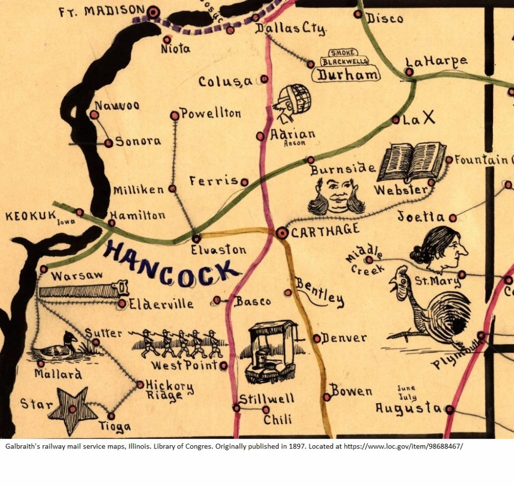
This comes from a map in the Railroad Collection at the Library of Congress. This one for Hancock County, Illinois, was one of Galbraith’s railway mail service maps, published in Chicago in 1897 and drawn Frank H. Galbraith. It can be seen completely at
https://www.loc.gov/item/98688467/

I’m trying to figure out what each of the pictures is for the locations in Hancock County, Illinois. Most I have figured out, but there are a few I don’t. Here are the ones I think I get:
- Webster–Webster’s dictionary (although that Webster had nothing to do with this Webster).
- Burnside–the guy has sideburns
- Plymouth–the Plymouth Rock rooster
- Stillwell–a well
- Warsaw–a saw
- West Point–military cadets
- Star–a star
- Augusta–he’s written “June July” above it
I don’t get the woman’s picture by St. Mary’s–is it supposed to be “St. Mary?” The other one I don’t get is the ball player near Adrian.

9 Responses
Check out what’s written under “Adrian” (grin). Adrian “Cap” Anson was a baseball player.
From Wikipedia:
Adrian Constantine Anson (April 17, 1852 – April 14, 1922), nicknamed “Cap” (for “Captain”) and “Pop”, was an American Major League Baseball (MLB) first baseman. Including his time in the National Association (NA), he played a record 27 consecutive seasons.[1] Anson was regarded as one of the greatest players of his era and one of the first superstars of the game.[2] Anson spent most of his career with the Chicago Cubs franchise (then known as the “White Stockings” and later the “Colts”), serving as the club’s manager, first baseman and, later in his tenure, minority owner. He led the team to five National League pennants in the 1880s. Anson was one of baseball’s first great hitters, and probably the first to tally over 3,000 career hits.
His contemporary influence and prestige are regarded by historians as playing a major role in establishing the racial segregation in professional baseball that persisted until the late 1940s.[3] On several occasions, Anson refused to take the field when the opposing roster included black players.[4] Anson may have influenced the most noted vote in 19th-century professional baseball in favor of segregation: a July 14, 1887 one by the high-minor International League to ban the signing of new contracts with black players.[5]
After retiring as a player and leaving the Colts, Anson briefly managed the New York Giants. He ran several enterprises in Chicago, including opening a billiards and bowling hall and running a semi-professional baseball team he dubbed “Anson’s Colts”. Anson also toured extensively on the vaudeville circuit, performing monologues and songs. Many of his business ventures failed. As a result, Anson lost his ownership stake in the Colts (by then known as the Cubs) and filed for bankruptcy. Anson was inducted into the National Baseball Hall of Fame in 1939.”
https://en.wikipedia.org/wiki/Cap_Anson
I’m stumped at St. Mary too!
Is the baseball player on Adrian, Adrian C Anson the WhiteSox 1st Baseman and manager? St. Mary’s, she looks kinda scary. Interesting map!
Could the ballplayer by Adrian supposed to be a reference to Adrian “Cap” Anson, a popular baseball at the time?
Would the lady possibly be “Joetta”? She’s located right on St. Mary’s, but I can’t imagine that drawing is St. Mary.
Very clever map! This should inspire us to prepare a map of this type of our favorite locations!
That is a very clever idea!
Thanks for posting this. I went looking for a Nebraska map by Galbraith and was not disappointed.
Here is an article with historic details and an analysis of the memory aids that Galbraith added to his maps. http://www.cartographicperspectives.org/index.php/journal/article/download/cp41-mason/607
Thanks for sharing that Debbie!
I just took a look at it. That’s a great article.